

Dugout Canoe Offers a Peek at History of the Region
Historic canoe was hauled out carefully by boat
An old dugout canoe discovered on the bank of the Tar River above Louisburg in 2001 raises interesting questions about trade and transportation in this region during the late eighteenth and early nineteenth centuries. Located by Rick Lambeth, the seventeen-foot-long vessel was recovered by staff members of the North Carolina Office of State Archaeology, assisted by a group of local men, including Louisburg Town Manager C. L. Gobble and Conrad B. "Buzzy" Sturges, Jr.
Tom Magnuson of the Trading Path Association in Hillsborough later assisted the Town of Louisburg in having the canoe treated with preservative by staff members of the state's Underwater Archaeology Branch at Fort Fisher. The canoe was returned to Louisburg, where it was placed in storage.

Historic river vessel was found along the Tar River
Currently the Tar River Center for History and Culture at Louisburg College is seeking grant funding so that the canoe can be placed in a museum-quality case and exhibited at Terrell Lane Middle School. Teachers and administrators within the Franklin County Schools are working with the TRCHC to craft a grant proposal that would fund construction of the exhibit and the development of lesson plans teachers could use to introduce their students to the canoe and its historical context.
Magnuson believes that the canoe dates from around 1800 and was actually one of two pontoons that were lashed together to create a platform on which farm products could be transported. A book on tobacco culture and commerce published in 1800 by William Tatham includes an illustration of such a vessel used by planters in Virginia to transport tobacco packed in hogsheads. On the other hand, single dugout canoes were a common means of conveyance along North Carolina's waterways during the eighteenth century. They continued to be used in the nineteenth century, and state archaeologists believe that the vessel in question dates from after 1800.

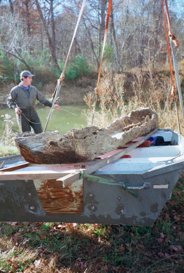
Preserving History. Tom Magnuson examines the Louisburg dugout canoe at the state's Underwater Archaeology Branch facility at Kure Beach. Photo courtesy of C. L. Gobble
Regardless of its age or exactly how it was used, the vessel points to Louisburg's strategic location in the Upper Tar River valley. According to a map published in 1733 by Edward Moseley, this portion of the Tar River was just north of a section of the colony that had been occupied by the Tuscarora Indians. After these native Americans were defeated in the Tuscarora War of 1711-1713, English, Scotch-Irish, and other settlers gradually began to push westward from northeastern North Carolina and southward from Virginia. Local historians believe that settlers first inhabited what is now Franklin County in the late 1730s. Members of the Massey family of Brunswick County, Virginia, in the 1740s purchased land on the Tar River at present-day Louisburg. Here the river featured the only ford in the region.
The Masseys apparently built a toll bridge across the river at this location prior to 1761. A bond signed in August of that year and now preserved among Granville County bridge records in the North Carolina State Archives [present-day Franklin County was a part of Granville County in 1761] states that William Freeman would be paid to build "a good Strong, Substantial Fraim'd Bridge agreeable to Law, over Tarr River [a] Little above the said William Massey's ..." The bridge was to be of sufficient strength to support carts, wagons, carriages, horses, and "other creatures." Two of the commissioners who oversaw the project, Osborn Jeffreys and Thomas Sherrod, certified that Freeman completed the bridge in November 1761.
By the time A Compleat Map of North-Carolina from an Actual Survey was published in 1770, what was commonly known as Massey's Bridge or Massey's Ford lay along a significant north-south road that ran from Petersburg to Cross Creek (now Fayetteville). Additional roads led to Halifax, on the Roanoke River, and to Hillsborough. The principal markets for farm products produced in the area were Petersburg and Richmond. In the eighteenth century, these commodities included tobacco, wheat (or flour milled from it), and livestock, especially pork. An account published in 1810 noted that Franklin County also produced cotton.
Magnuson envisions Louisburg as a "multi-modal" transfer point. Some farmers likely brought their produce here on the river. From Louisburg, farm products were hauled overland by wagon or cart, eventually arriving in Petersburg. Hamilton Fulton, a civil engineer hired in 1819 by North Carolina to help the state develop such internal improvements as canals, soon published a report noting that farmers from Franklin, Granville, Halifax, and Warren counties were transporting their tobacco and wheat to Petersburg using existing roads.
Additional research will be required to understand more fully the commercial and transportation history of the Upper Tar River region.
Published in The Franklin Times on July 30, 2015.
Maury York is director of the Tar River Center for History and Culture at Louisburg College. For this article, he relied heavily on information found in Colonial North Carolina in the Eighteenth Century: A Study in Historical Geography, by Harry Roy Merrens (UNC Press, 1964) and The Franklin County Sketchbook, edited by George-Anne Willard (Franklin County-Louisburg Bicentenary Committee, 1982). He wishes to thank C. L. Gobble, Nathan Henry, Tom Magnuson, and Mark Pace for their assistance.