

Reprinted Louisburg Maps from 1882 Available
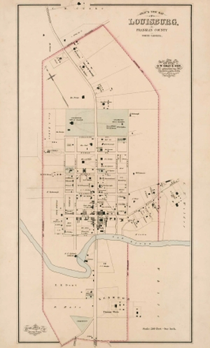
The Tar River Center for History and Culture Foundation has published a high-quality reprint of Gray’s New Map of Louisburg, Franklin County, North Carolina, which originally appeared in The National Atlas (Philadelphia: O. W. Gray & Son, 1882). Printed on heavy acid-free paper and measuring 31 x 18 inches, the map is suitable for framing. The cost of the map is $20; proceeds from sales will support the work of the Tar River Center for History and Culture at Louisburg College. Copies of this handsome map will be available for sale at the Franklin Male Academy building on the college campus on the following days between 3 and 5 p.m.: Monday-Thursday, April 11-14, and at other times by appointment. The academy building is located on Cedar Street in Louisburg. Copies can be mailed for an additional charge of five dollars.
The map provides detailed information about the Louisburg at a time when it was poised for significant growth. Based on a survey by engineers who visited the town, the map is one of at least ten such maps of Tar Heel municipalities produced by the company.
The firm’s founder, Ormando Wyllis Gray (b. 1829), a native of Vermont, studied surveying and civil engineering at Norwich Military Academy in that state. During the 1850s and 1860s, Gray worked for a company that produced county and state maps as well as special surveys in Canada, New England, and the Middle Atlantic States. He moved to Camden, New Jersey, in the early 1870s, and he and his son Frank established a map and atlas publishing firm in Philadelphia.
The company’s National Atlas appeared in several editions during the 1870s and 1880s, offering users a wealth of information: topographical maps of the United States and Canada; historical and statistical information; lists of cities, towns, villages, and post offices; and “special railway and scientific maps and articles.” It appears that the company solicited pre-publication subscribers, in some cases promising to include local information. New York and North Carolina were among the states for which O. W. Gray & Son produced special editions. Published in 1882, the atlas for North Carolina included maps of Durham, Kinston, Louisburg, Oxford, Monroe, Salisbury, Tarboro, Wadesboro, central Wilmington, and Wilson.
The company in 1881 sent Jacob Chase, a civil engineer, to work in North Carolina. The Raleigh News and Observer on May 8, 1881, printed an excerpt from a recent issue of the Tarboro Southerner stating that Chace had spent “some days” in that town. The piece noted that Chace and his team of surveyors and topographers were surveying North and South Carolina for a new map of both states and that this work involved travel from the tidewater region to the mountains. This effort may have resulted in the publication of Gray’s New Map of North Carolina and South Carolina, which O. W. Gray & Son issued in 1881. It is likely that during this time Chace and his staff surveyed North Carolina towns, including Louisburg, for the maps noted above.
Produced with the assistance of George Chase, assistant engineer, the Gray map of Louisburg is a boon to local historians. It shows the locations of individual residences as well as commercial, industrial, and institutional buildings, giving some idea of their size and configuration. A line in the Tar River indicates the location of the old dam, with B. F. Clifton’s cotton gin and Jordan Jones’s grist mill on either side. Many property owners are listed. Even elaborate walkways and driveways associated with Louisburg Female College and several residences, including those of Anna Long Fuller on Main Street and Dr. William R. King near Elm Street, are depicted. The large home of John H. Williamson is shown just north of the African-American Presbyterian church on South Main Street. Also depicted is Kenmoor, the estate of Thomas White.
The map was published just prior to the construction in 1885 of a spur line of the Raleigh and Gaston Railroad from Franklinton to Louisburg, which fostered an economic upswing that significantly changed the town. For this reason, the map makes a valuable contribution to our knowledge of Louisburg as it was shortly after the Civil War.
For additional information, please contact Maury York, director of the Tar River Center for History and Culture at myork@louisburg.edu or at (919) 497-3252. For those wishing to purchase a copy by mail, checks for $25 should be made payable to the TRCHC Foundation and mailed to York at Louisburg College, 501 North Main Street, Louisburg, NC 27549. Maps will be shipped in a heavy mailing tube.
Published in The Franklin Times on April 7, 2016.
Maury York is director of the Tar River Center for History and Culture at Louisburg College.