

Sanborn Maps Help Unravel Development of Towns
By Maury York
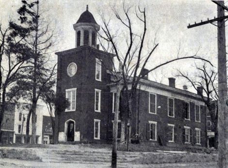
An early 20th Century view of Franklin County's courthouse
A series of fire insurance maps published during the late 19th and early 20th centuries by the Sanborn Map Company of Pelham, N.Y. reveal much about the physical development of the towns of Louisburg and Franklinton.
The Sanborn Map Company published detailed maps of cities and towns throughout the United States from 1867 to 1967, to aid insurance companies in making informed decisions about insuring properties.
Printed in color, the highly detailed and accurate maps depict businesses, residences, and institutional buildings, including churches and schools.
They indicate the type of building materials used and the number of stories in each building. For many commercial and institutional buildings, the maps indicate the source of heat.
The presence or lack of water mains and fire hydrants provided insurance companies with further evidence of the risk of fire.
New maps were published at regular intervals, depending upon how fast each town or city grew.
One can use the maps not only to find out details about a specific building, but also to understand how a town developed. During the late 19th century, commercial buildings usually were of frame construction.
Devastating fires often ravaged business districts. Gradually, towns required owners to construct their businesses of brick, thus mitigating the risk of fire.
Sanborn maps clearly reveal this trend. The company published a map of Franklinton in May 1926 and subsequently updated it in December of 1934.

Louisburg, 1914
Maps of Louisburg date from September 1893, March 1898, February 1904, March 1908, January 1914, March 1922, and January 1930 (updated in October 1939).
The January 1914 map of Louisburg clearly shows the "footprint" of the Franklin County Courthouse as it looked prior to renovations in the 1930s and 1960s.
A distinctive bell tower protruded from the west facade. This can be seen in a postcard view of the building, which dates from around 1907.
A variety of commercial buildings, including Hart's Tobacco Warehouse, hardware and furniture stores, and barber shops surrounded the courthouse square.
The Gem Opera House stood behind the courthouse, on the southwest corner of Market and Nash Streets.
Anyone with a computer and Internet access can examine Sanborn maps of Louisburg, Franklinton, and other Tar Heel towns. The Franklin County Library System (http://www.franklincountync.us/services/library) provides access to maps through NC LIVE.
In this version, the maps are shown in black and white. At the North Carolina Maps Web site (http://www.lib.unc.edu/dc/ncmaps/), Sanborn maps appear in color. In this version, however, only maps from 1922 and earlier are included, because later maps are subject to copyright.
Sanborn maps are a boon to local historians, preservationists, and school children. Take a look and see for yourself.
Published in The Franklin Times on July 11, 2013.
Maury York is director of the Tar River Center for History and Culture at Louisburg College.
Credits: View of Courthouse: North Carolina Collection Photographic Archives, Wilson Library, University of North Carolina at Chapel Hill; Sanborn Map of Louisburg, 1914, courtesy of NC LIVE.